THE CITY OF SERRES
TOPOGRAPHYTERRAIN
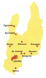
The Kapodistria Bill of 1998 extended the boundaries of the Municipality of Serres, so that it now includes the following areas: the city of Serres itself, Agios Ioannis, Kato Metochi, Krinos, Xirotopos, Elaionas, Chrysopigi, Oinousa, and Chionochori.The city of Serres is situated in the centre of the Prefecture of Serres. There is a marked contrast between the lie of the land in the northern and southern parts of the prefecture.The area to the north of the city is hilly and mountainous. A number of streams - including the Christou, the Lefkona, the Kamenikion, and the Agiou Ioanni - spring up in the high ground to the north of the city before flowing south.The southern part of the prefecture consists of a plain through which the River Strymona flows. It is generally flat.
CLIMATE
The climate is generally dry, with occasional semi-wet spells. There is no shortage of rain in the winter. The average yearly temperature is 15.2°C, the average maximum temperature is 24.7°C, and the average lowest temperature is 5.6°C. August is the hottest month and has the least rainfall, while January is the coldest month of the year.It must be stressed that the climate in the south of the prefecture, greatly affected as it is by the Belitsa trough and the River Strymona, is wetter than in the more arid north.
POPULATION
Serres was liberated by the Greek army on June 28, 1913. The city was, however, in an appalling state, since the Bulgarians had burnt a large part of it to the ground prior to withdrawing. It is estimated that half of the 30,000 or so people living in the city were left homeless.The population at this time cannot be stated with any accuracy. The data collected by the Greek army seems to date from after the Second Balkan War and the signing of the Treaty of Bucharest in August 1913 - that is to say, after the population exchange - while the various pre-1913 statistics that we have at our disposal present radically different figures. This inaccuracy can be attributed to the constant emigration that was taking place at the time - especially on the part of the city's Muslim population between 1905 and 1913 - as well as to different criteria used in the measuring process.
The situation was no different after 1913: constant population movements once again made it impossible to measure the population with any accuracy. The Greeks from Stromnitsa, Meleniko, and Petritsi moved into Greek areas in August 1913 by order of the Greek army; and then there were the refugees from Bulgaria, Thrace, Asia Minor, the Caucasus, and elsewhere that started to arrive in Macedonia at the end of June 1915. All in all, 21,306 refugees were to settle in Serres in this first wave of upheavals.The First World War also led to population change. The battles along the Strymona, the enforced movement of populations into Bulgaria, and other such events had their effect on the area's demographic make-up. The signing of the Treaty of Neuilly in November 1919 along with the ensuing agreement between Greece and Bulgaria re population exchange, saw more Greeks moving out of Bulgaria, while, at the same time, Greeks started to arrive in Greek harbours from Eastern Thrace, Asia Minor, the Black Sea, and other parts of the Ottoman Empire. The National Statistics Office record the population of the city in 1920 at 14,564.
A little later, the Asia Minor catastrophe and the signing of the Treaty of Lausanne (July, 1923) brought a new wave of refugees to Macedonia. By 1928, over 70,000 refugees had settled in the Prefecture of Serres. Their first years in a new land were marked by a dramatic decline in public health, and the refugees fell victim to dysentery, typhus, and malaria.According to the General Housing Bureau, the Refugee Resettlement Committee had placed 13,538 refugees in the city of Serres by the end of 1928, and 56,884 in the rest of the prefecture. The National Statistics Office records the city population at 29,640 in 1928.The completion of the population exchanges brought religious uniformity to the area (0.9% Muslim). Linguistically speaking, the majority of the Turkish-speaking and some Slav-speaking Greek villages gradually switched to Greek.
A natural rate of population growth can be seen from 1928 on; between 1928 and 1940 the population of the city rose by some 5,000 inhabitants.The Second World War and the Civil War led to a decrease in the population of the prefecture as a whole during the 1940s, although the population of the city of Serres itself increased. The lawlessness which prevailed in the countryside at the time led many people living in rural areas to move into the city, thereby placing the cities more centre stage in Greek life.The city of Serres witnessed a continuous rise in population from the end of the war onwards. The National Statistics Office gives us these figures: 37,207 official residents in 1951; 40,626 in 1961; 41,091 in 1971; 46,317 in 1981; and 51,010 in 1991. Preliminary results from the 2001 census show the population to be in the region of 56,000. Of course, the real population of the city has always been considerably higher than that recorded in the censuses.A comparison between the increase in the population of the city, and the slight fall discernible in the population of the prefecture as a whole, reveals a driving force behind the development of the city; a driving force which owes much to the development of the city in those fields affecting the increase and decrease in population. In Serres, as in most Greek provincial cities, the decades following the Second World War saw the old middle classes quitting the provinces in favour of Athens and Thessaloniki, and newcomers from the countryside moving into the vacuum they left behind.
ENVIRONS
Recent decades have witnessed the rapid development of certain rural areas in the prefecture of Serres in line with that of the city of Serres itself. The phenomenon is marked in both Eptamyloi and Lefkonas, areas a short distance from the city. Eptamyloi, to the east of the city, was built up as a result of population increase in the city itself; while Lefkonas (which has been a municipality since 1998) to the west of the city has developed as a result of its proximity to the Serres Industrial Zone and its key position on the main highways joining Serres to Thessaloniki and Promachonas, on the border with neighbouring Bulgaria.
Both Eptamyloi and Lefkonas have developed into suburban areas, and their population make-up has changed in line with changes in local production, so that it no longer differs from that of the city itself. To the east of the city, Oinousa has also enjoyed considerable growth. The group of villages to the south of the city - that is to say, Mitrousi, Monovrisi, Neochori, N. Skopos, Skoutari, Konstantinato, and K. Kamila - have retained their rural character despite the intense development of light industry in the area. The inhabitants of these villages turn to the city of Serres for their shopping needs, and for alternative social, cultural and recreational activities. The greater part of their produce - mostly fruit and vegetables - is sold in Serres, and they invest the majority of their farming income in the city; a not inconsiderable sum due to the fertility of the local irrigated land.The terrain to the north of the city does not lend itself to large towns, but its wonderful natural environment - forests of particular beauty - has led to the development of the Lailia ski centre and the construction of holiday homes in Chrysopigi and Elaionas.
THE DEVELOPMENT OF THE BUILT ENVIROMENT
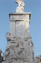
The great fire of 1913 caused huge damage to the city of Serres. Some 4,050 of its 6,000 houses were burnt to the ground along with 1,000 shops. The Greek community suffered the greatest damage: eighteen of its twenty-one churches were lost, along with all its educational institutions.The city's ensuing built environment was thus determined by the disaster of 1913 and the settlement in the city of refugees after the Asia Minor Catastrophe. Refugee districts were built in accordance with specific town planning and architectural models. The sheer numbers of refugees in the city make it clear just how much building had to take place. The natural barrier formed by Koula Hill to the north, the streams of Agia Varvara to the west and Agion Anargyron to the east formed natural barriers beyond which the city did not grow.
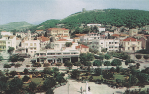
The starting point for the rebuilding of the city of Serres was what remained of the old town. The new town gradually expanded southwards from here, where the ground was most suitable for building.There was a Jewish community in Serres until the Second World War. The Jewish quarter lay close to Emporiou Square. The former Alliance Israelite school has been saved from demolition and now houses the 6th Primary School of the city.The city's 17 parishes each maintain an individual character and built environment. However, the large number of blocks of flats in certain areas is gradually making them hard to tell apart. The city's peripheries are mainly residential, while more central areas are characterised by a mix of residential, commercial, and recreational functions which dictates their appearance.
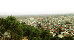
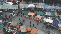
The size of the local market combined with the scale of the city made the development of local centres unnecessary; hence the city's clear separation into central and non-central areas. The one exception to this rule is the long line of recreational buildings which stretches along the Agion Anargyron valley in the eastern part of the city.Emporiou Square and the Public Market is the focus for the city's commercial activities, based as they are on foodstuffs. A short distance north of Emporiou Square is Eleftherias Square, the city's recreational centre, where restaurants, clubs, and cafes line the sides of the square, and the pedestrian zones which radiate off the square into the city's old commercial centre. There are few large public areas in the city itself; the only such place in the built-up part of the city being the area between the parishes of the Timios Stavros and Kiouplia, where you can find a primary school and an open-air municipal theatre. However, the absence of purpose-built parks in the city - especially from its heavily built-up central areas - is compensated for by the abundance of greenery to be found in the Koula area in the northern part of the city. The Agion Anargiron valley in the north-east of the city is graced with exceptional natural beauty, combining greenery with sports facilities and a number of tavernas, coffee bars, bars, and an open-air cinema where people of all ages can enjoy themselves. This surely makes up for the absence of similar facilities in the city itself.